


 Mirella Pandjaitan
 Mar 06, 2025
Monsoon season in Jakarta can be tough. The air gets humid then turns to a chillier breeze when the moon shines. Top it off with the worsening congestion after rainfall.
But the most detrimental facet of them all? Floods.
The bustling capital of Indonesia has been familiar with the devastating impacts and is vulnerable to severe floods for hay-time, especially during heavy rains. Allow us to unveil the causes of floods in Jakarta, their consequences, and the measures being taken to mitigate the risks.
When does the monsoon season end in Jakarta?
Any newcomer to Jakarta from abroad and other Indonesian cities is normally warned of the catastrophic flooding taking place every monsoon season. And any residents of the Jabodetabek area (Jakarta, Bogor, Depok, Tangerang, Bekasi) are no strangers to the phenomenon.
The monsoon season typically lasts until the first quarter of the year. In 2025, the Head of the Meteorology, Climatology, and Geophysics Agency (BMKG), Dwikorita Karnawati, announced that the rainy season is expected to last until the end of March.
"April will mark the transition from the rainy season to the dry season. The peak of the rainy season in most parts of Indonesia typically occurs from January to February," she explained.
Given this, Karnawati urged the public to remain vigilant for the potential of extreme weather events, which continue to occur frequently and almost uniformly across the entire archipelago. In Jakarta, fierce winds accompanied by intense downpours lasting for days and nights accumulate to fallen trees on the road and floods.
Why does Jakarta often flood?
This is a recurring question. It’s not about carelessly tossing trash around - more factors contribute to playing a role. Consider Jakarta’s geography and inadequate drainage capacity.
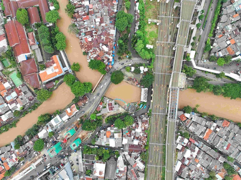
Situated on the northwest coast of Java, Jakarta is a lowland area with an average elevation of merely 7 metres above sea level, and 40 per cent of the city lying below sea level. This type of topography makes it highly susceptible to floods. Additionally, its position, traversed by numerous rivers, is another factor that exacerbates the city’s flooding issues.
The primary causes of floods in Jakarta are interconnected and collectively worsen the impact of flooding in the capital city.
Climate change
Rising sea levels and increasingly extreme weather patterns are key players to Jakarta’s vulnerability as well. Intensified rainfall patterns lead to heavier and more frequent storms. Rising temperatures cause increased evaporation, resulting in more moisture in the atmosphere, which then leads to extreme rainfall. Also, sea level rise, a direct impact of climate change, exacerbates coastal flooding in Jakarta, particularly during high tides.
Local rainfall floods
Heavy rainfall over an extended period in Jakarta can lead to flooding. The rainwater fills the drainage systems and low-lying areas around the city. When the capacity of these drainage systems is exceeded, the water overflows and floods residential areas.
The drainage system in Jakarta is designed to handle rainfall up to 120 mm per day. However, extreme rainfall sometimes surpasses this capacity. For example, on 1st January 2020, rainfall reached 377 mm in a single day—setting a record high in 24 years. This caused many parts of Jakarta to be submerged.
Rapid urbanisation
The city's explosive growth and uncontrolled development have led to the destruction of natural drainage systems. Thus, increased impervious surfaces, such as buildings and roads, prevent rainwater from being absorbed into the ground.
The destruction of natural ecosystems, overburdened drainage systems, and excessive groundwater extraction contribute to land subsidence, making the city more prone to flooding. Additionally, poor waste management and blocked drains further hinder water flow, worsening flood risks. These combined factors create a vicious cycle.
River floods
Jakarta's low-lying position and the fact that it’s crossed by 13 rivers make it highly vulnerable to river floods. The Ciliwung River bisects the city, along with other rivers and waterways. Heavy rain in upstream areas, such as West Java and Banten, causes the rivers to carry water downstream toward Jakarta.
When the volume of water exceeds the river’s capacity, it spills over into the residential areas along the riverbanks. This worsens the flooding in Jakarta, especially when heavy rainfall occurs simultaneously in both the upstream areas and the capital.
Tidal floods
Indonesians call it “banjir rob”, which means floods occur when seawater inundates the city’s coastal areas. The subsidence of land in northern Jakarta aggravates the situation, allowing seawater to flow inland more easily and cause flooding.
What are the impacts of the phenomenon?
Let’s take a look at the most recent flooding in Jabodetabek for an idea. The persistent rainfall on 2nd March 2025 has caused the water levels in several rivers to rise. Several reports suggested that the water levels at various water gates have reached alert levels.
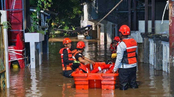
At least 62 neighbourhood units (RT) were flooded, reported the Jakarta Disaster Mitigation Agency (BPBD Jakarta) on 3rd March, with further data claiming more neighbourhood units underwater due to the overflow of the Ciliwung, Pesanggrahan, and Krukut Rivers.
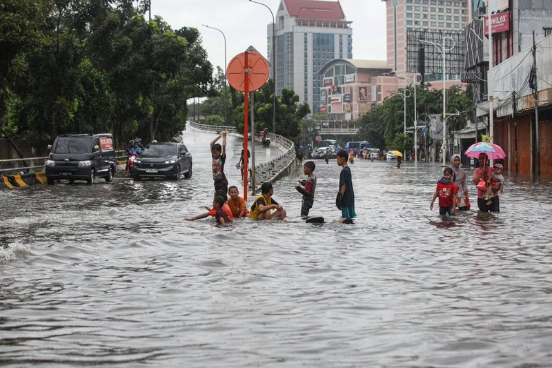
Water also inundated main roads. Parts of the roads in areas such as Margonda Depok, Daan Mogot, and Kedoya in West Jakarta were covered in water.
Public transportation operations were disrupted as well. From TransJakarta schedules being delayed to the KRL commuter line having to halt certain routes, particularly those heading toward Bekasi, the floods highly halted mobility.
Contaminated floodwaters can spread waterborne diseases such as typhoid, hepatitis A, and diarrhoea, posing significant health risks to affected communities. On top of that, extensive damage to homes, infrastructure, and public facilities led to significant financial losses.
Thus, thousands of residents are often forced to evacuate their homes and seek shelter in temporary accommodations during severe flooding. The Head of the Data and Information Centre at BPBD Jakarta, Mohamad Yohan, reported that as of 5th March, at 7 AM, remaining floodwaters were still affecting 89 neighbourhood units and two road sections with at least 4,258 people were displaced due to the disaster.
Loss of life regrettably occurs as well. Floods have claimed numerous lives over the years, with the most recent major flooding in 2020 resulting in the deaths of at least 60 people. The recent flood has reported a child under the age of 5, identified as A, was swept away during the flood evacuation process in Kebon Baru, South Jakarta. A was found dead on as the body was discovered by local residents after the water levels of the Ciliwung River dramatically receded.
What are the flood control strategies in Jakarta?
Efforts to control flooding in Jakarta involve both the Jakarta Provincial Government (Pemprov Jakarta) and the public.
Strategies by the Jakarta Provincial Government
Stricter regulations on land use and development aim to reduce the negative impact of urbanisation on flood risk. Indeed, that’s insufficient.
Investment in infrastructure projects such as the construction of dams, canals, and drainage systems to improve the city's flood defences have been ongoing. Three flood control systems focus on the main drainage system, secondary drainage, and pump reservoir systems. These systems aim to expedite the flow of water to storage or disposal sites.
Furthermore, the Water Resources Agency (DSDA) operates water pumps to control water pooling. The DSDA currently manages 495 stationary water pumps and 327 mobile pumps spread across the city to drain floodwaters from vulnerable areas.
Another measure involves the use of heavy machinery for flood mitigation. These machines are used to dredge ponds, reservoirs, rivers, and drainage channels to increase storage capacity and improve water flow.
"Jakarta has a sizable budget for flood control. But of course, it won’t be resolved in a year with limited funds. Now, with support from the National Strategic Projects (PSN), we will focus more on improving the Ciliwung," stated Jakarta’s Deputy Governor, Rano Karno on 4th March.
Strategies by the community
The community’s vital role in flood control includes the use of vertical drainage systems. This method manages rainwater by capturing it and allowing it to naturally seep into the ground. Besides, vertical drainage also serves as a backup water source during the dry season.
Relocating vulnerable communities is also crucial for managing flood risks. Karno visited several flooded areas recently, where he offered residents in Kampung Melayu and Bidara Cina the option to relocate to the Jagakarsa flats in South Jakarta.


